11″x14″ Colored Map of the West Indies in 1727. Displayed on corrugated board and sealed in a protective sleeve.

West Indies Color Map
$10.00
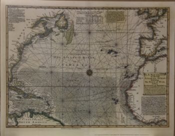
THE WEST-INDIES &C. WITH ADJACENT COUNTRIES
This print is an offset lithograph reproduced from an original published in 1727 by Herman Moll.
Original image size 7.5 in x 10.2 in (19 x 26 cm)
Herman Moll was a Dutch engraver, geographer, and bookseller. Moll moved to London in the 1680s and was one of the preeminent cartographers of his time producing several series of maps and atlases throughout his career. He rendered this map in 1727, depicting the West Indies and the adjacent countries, including English, Spanish and French lands of the 1700s. This map includes many important details, including ports of trade, fortifications, and native settlements. Moll based this map on the observations and reports of William Dampier (1651-1715) & Woodes Rogers (1697-1732) and scientist Robert Hooke, who furnished Moll with information and sketches of this region gathered from their first-hand experience. This map contains exceptional detail of the trade winds and routes of travel throughout the Gulf of Mexico and the Caribbean and major settlements of the English, Spanish and French. This map was originally printed in Herman Molls Atlas entitled “A Set of Thirty-Two new and correct maps of the principal parts of Europe, &c. : with the great or post-roads, and principal crossroads, done in the year 1725, 1726 and 1727.” This is map number 32 of that publication.
Related products
-

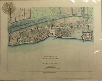
Town and Capital East Florida Color Map
$10.00 — SKU: 13702-L -
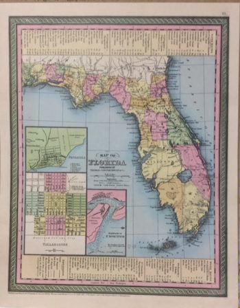
Florida 1850 Color Map
$10.00 — SKU: 13702-D -
Bowen Color Map
$10.00 — SKU: 13702-G -
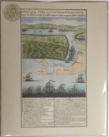
Town & Castle Silver 1740
$10.00 — SKU: 13702-F